Golf Geomatics specializes in high-tech land surveying solutions tailored for golf courses. With over 15 years of experience, we use cutting-edge technology to deliver precise results efficiently and cost-effectively. From course design to maintenance, we help golf facilities optimize every square yard.

15

YEARS of experience

50%

cost savings vs traditional survey methods

3x

faster data turnarounds

1

professionally licensed surveyor and mapper

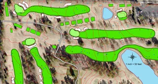
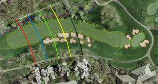
At Golf Geomatics, we leverage cutting-edge LiDAR technology, high-precision GPS, and robotic total stations to deliver unparalleled ground mapping for golf courses. Our advanced surveying methods ensure precise slope analysis, enabling accurate historical documentation and seamless renovations. We provide comprehensive solutions tailored to the needs of golf course owners, superintendents, and architects. Trust us to transform your course with innovative technology and meticulous attention to detail.
With over 15 years of land surveying and construction stakeout experience, we specialize in grade staking and building robust control networks to support every phase of your golf course analysis and construction project. We deliver accurate ground mapping and staking to guide precise cut-and-fill operations.

Golf Geomatics serves golf course architects, superintendents, irrigation consultants, and The entire golf industry.